
How Developers Can Avoid Selecting a Site That Turns Into a BNG Headache
Biodiversity Net Gain (BNG) has forced developers to fundamentally shift their approach to property development since the legislation went into effect in February. Now, developers must enhance biodiversity as part of every new project. After receiving planning permission but before beginning development, developers must submit a Biodiversity Gain Plan and receive approval from the Local Planning Authority (LPA). However, if developers wait until the application stage to begin thinking about BNG, they may face unforeseen challenges that ultimately delay or derail the development.

Don’t let BNG requirements delay your project. Taking BNG into account early during site selection can help you avoid costly setbacks and stay ahead of planning requirements. This blog explores how developers can prevent sites from becoming a BNG headache by calculating BNG early on in the development cycle, during site selection. This can help them steer clear of sites that will be too costly or won’t be able to comply with the legislation.
BNG in the Development Cycle
When developers submit a Biodiversity Gain Plan, they must demonstrate how they will achieve a 10% net gain in biodiversity. The biodiversity value is measured using the statutory biodiversity metric, which assigns “biodiversity units” using a scoring system based on the habitat types present, their condition, and the area they cover. Each project must include a 10% net increase in biodiversity units, either by creating higher value habitat types or improving the condition of existing habitats, more-than-compensating for any habitat loss due to the development. If possible, the habitat enhancement must happen onsite. If onsite gain is not feasible, the requirements can be met with units created off-site or by purchasing statutory credits as a last resort.
For the planning application, the baseline habitat survey needs to be conducted by a qualified ecologist, except for some small developments where the small sites metric can be used by a competent person with knowledge of BNG. The ecologist calculates the score by entering the survey results into the statutory biodiversity metric calculation tool. The ecologist also inputs the planned habitat enhancements in the same calculation tool for submission to the LPA. Once the Biodiversity Gain Plan is approved, the developer is then responsible for implementing the habitat plan and monitoring to provide evidence that the enhancements are maintained for at least 30 years.
However, waiting until this stage can create serious challenges. As urged by government guidance, developers should consider biodiversity net gain early in the development process and factor it into site selection and design. Developers need a reliable, systematic approach for considering BNG that is tailored to their requirements during these early stages.
Considerations During Site Selection
During site selection, developers need to assess whether it will be feasible to deliver BNG on each potential site and at what cost. This is a critical cost to consider, as off-site units are currently averaging £30,000 and statutory credits are exceeding £40,000 At this stage, developers may be considering many different sites, so they need just a quick snapshot of what BNG will mean for each of them. Essentially, they need an easy way to get baseline habitat maps and calculate the biodiversity units.

Gentian’s Online Platform
But getting accurate habitat maps can be a challenge. Sending an ecologist to each site to complete a habitat survey is expensive and time-consuming, and potentially problematic if the developer doesn’t have access to the site. There is some habitat mapping data available online, such as the Living England Habitat Map, but this data is far too coarse at 10 metre resolution to be useful for assessing specific sites for BNG. What developers need is a fast, remote solution that gives them access to precise BNG data, helping them make informed decisions early on.
Gentian’s Instant Habitat Mapping Solution
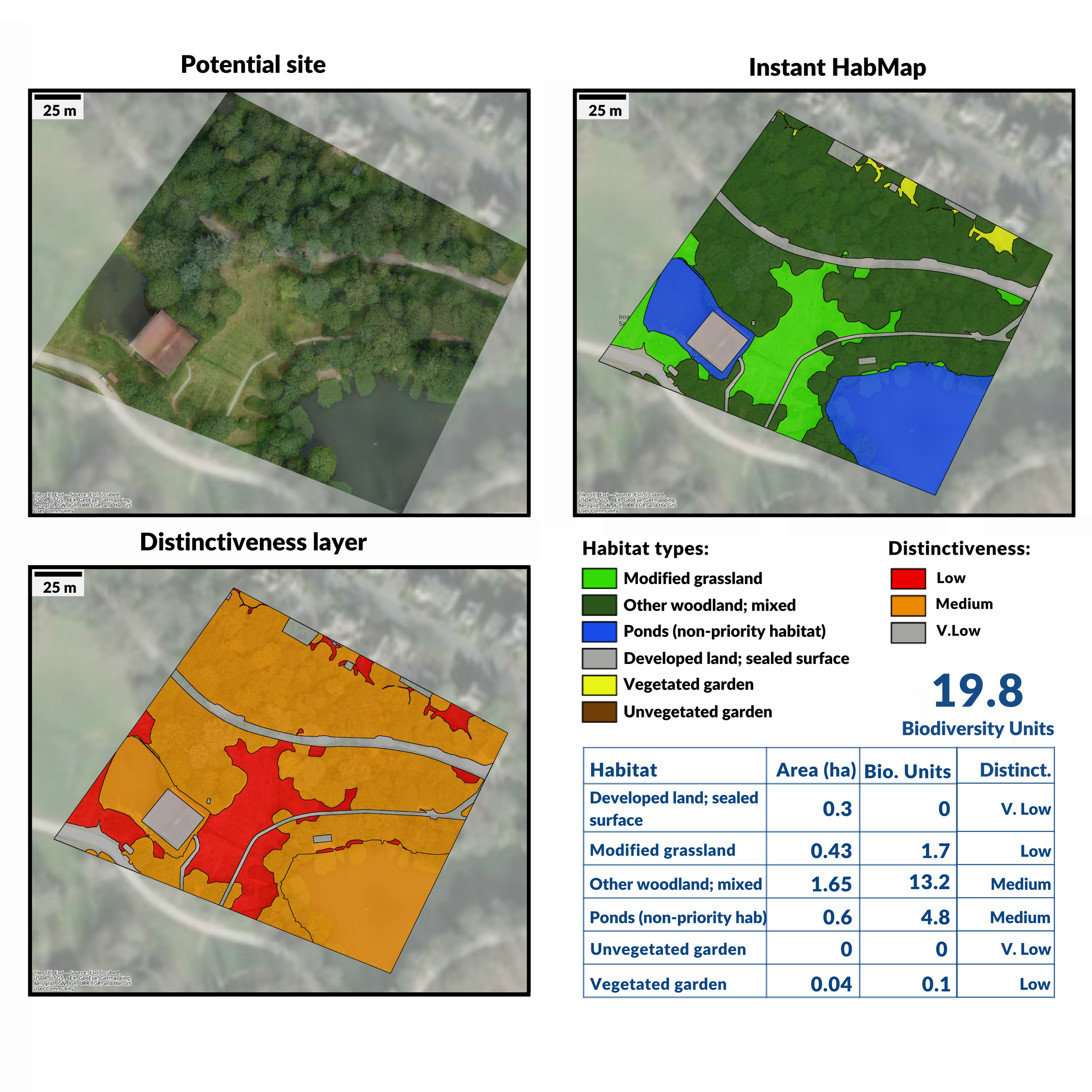
Gentian’s Instant Habitat Mapping
At Gentian, we have designed an instantaneous habitat mapping tool that is perfect for scoping site sites quickly for BNG. We specialise in applying AI to analyse high-resolution aerial and satellite imagery, and we have applied our technology to create a BNG-tailored solution.
The product uses sub-metre resolution imagery captured within the last three years, and the classifications are aligned with the statutory biodiversity metric.
Our AI has been trained using on-the-ground ecologists’ surveys, which have also enabled independent validation. On one site, the ground survey found a total of 5.80 biodiversity units. Our instantly generated map for the same site: 5.81.
Using our tool is straightforward: Simply submit your potential sites via our online platform or API, and within minutes, you’ll receive a habitat map and a table with the biodiversity unit calculations for each site. This gives developers exactly what they need for site selection. They can easily visualise the habitats on each site and the potential for on-site enhancements, while also knowing how many biodiversity units are present to assess the cost and feasibility of achieving BNG.
Contact Us
Ready to streamline your BNG compliance? Get started now by filling out the form below and a member of our team will be in touch to discuss how our instant habitat mapping tool can help your projects.