Ecological Surveys
Gentian provides high-resolution, AI-powered ecological surveys that are faster, more efficient, and highly scalable compared to traditional fieldwork. Whether you're planning development, assessing habitat value, or managing land portfolios, our remote ecological insights deliver the clarity and confidence you need to act.
.jpg?width=6016&height=4000&name=henry-perks-WOUCHo4zlDg-unsplash%20(1).jpg)
How our ecological surveys work
Gentian delivers fast, remote ecological surveys using high-resolution satellite imagery and advanced AI. We map habitat types and detect changes in ecological features, without relying on seasonal fieldwork.
Our models are trained to recognise a wide range of land cover classes and habitat indicators, ensuring accurate and consistent data across urban, rural, and natural landscapes.
Whether you’re scoping a site, monitoring a portfolio, or supporting ESG goals, our ecological surveys provide scalable insights to guide better environmental decision-making.
.jpg?width=2000&height=1333&name=marc-pell-oWRVjFQIwAY-unsplash%20(1).jpg)
Submit your site boundary
Use our intuitive online platform to define the precise location and area of your assessment.
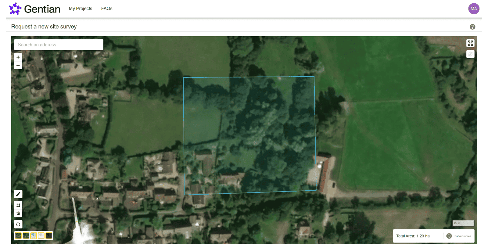
Wait for your satellite-based survey
Completed remotely within minutes to days, utilising our advanced AI and expert guidance (for premium solutions).
Receive expert-reviewed reports
Including biodiversity metrics, habitat maps, and other ecological baselines.

How do ecological surveys work?
Ecological surveys assess the habitats and species present on a site to support planning, conservation, and land management. They typically begin with a desktop study, reviewing existing data like aerial imagery to understand the site’s ecological context. An ecologist then visits the site to map habitats using systems such as UKHab or EUNIS, assess habitat condition, and identify any protected species. The findings are analysed and compiled into a report with maps, biodiversity unit calculations, and recommendations for mitigation or enhancement.
.jpg?width=2200&height=1650&name=neil-macc-COcF_5cewN0-unsplash%20(1).jpg)
How does Gentian differ?
At Gentian, we enhance this process by using remote sensing and AI. Instead of relying solely on site visits, our platform allows users to submit a site boundary and receive detailed habitat and biodiversity insights using up-to-date satellite imagery, interpreted by our algorithms and reviewed by our expert ecologists. This approach enables:
- Faster results
- Lower costs
- Early-stage decision-making
- Scalable assessment across large areas
.jpg?width=3456&height=2304&name=tania-malrechauffe-uajvdr609Rs-unsplash%20(1).jpg)
Why choose Gentian?
Gentian combines deep ecological expertise with cutting-edge technology to deliver better, faster, and more scalable ecological insights. By combining satellite imagery, AI-powered analysis, and expert review, we provide clear, reliable data to support informed decisions across planning, land management, and sustainability projects.
.jpg?width=1200&height=900&name=aaron-brunhofer-SwwoxDZrW5I-unsplash%20(1).jpg)

Speed
Receive results in days or even minutes, not weeks or months.

Coverage
Survey any site, anywhere, from single plots to national portfolios.

Accuracy
We use sub-50cm imagery and rigorously trained AI models.
.png?width=100&height=100&name=icons8-trust-100%20(1).png)
Insight
Data reviewed by expert ecologists for clarity and confidence.
Landowner transforms its biodiversity monitoring, demonstrating measurable net gains across 50+ Sites
A large UK cemetery and crematoria operator used Gentian True Sage to map 50+ sites in 90 days, proving a 29-unit biodiversity uplift. The platform cut costs, streamlined reporting, and ensured scalable, evidence-based tracking.

.png?width=1540&height=558&name=GFSA_DigitalBadge_withoutyear_2024%20(1).png)


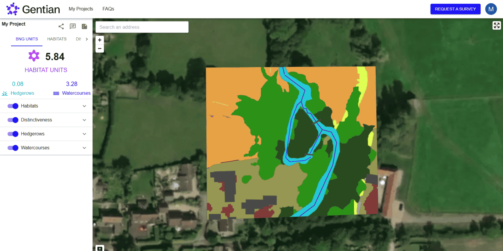
Biodiversity Net Gain (BNG) Assessments
Gentian’s Biodiversity Net Gain (BNG) Assessments use advanced AI and high-resolution satellite imagery to deliver fast, accurate habitat surveys for site scoping and selection.

Biodiversity Monitoring, Reporting and Verification (MRV)
Our AI-powered MRV solutions deliver accurate, remote assessments of habitat change and ecological condition over time, aligned with TNFD, CSRD, and other global standards.
.jpg?width=1600&height=1067&name=claudel-rheault-ZVbv1akA-l4-unsplash%20(1).jpg)
Habitat Mapping
Gentian uses AI and satellite imagery to map habitats with speed and accuracy. Ideal for baselines, monitoring, or biodiversity risk insights—giving you a clear view of the landscape.

Phase 1 Habitat Surveys
Gentian delivers remote Phase 1 Habitat Surveys using AI and high-resolution satellite imagery—providing rapid, cost-effective alternatives to traditional field-based assessments, whether for early-stage scoping, risk screening, or desktop baselines.