FAQs
Have questions? We’ve got answers.
Below are some of the most common inquiries we receive about Gentian, our products, use-cases, technology and pricing.

About us
Who is Gentian?
Gentian is a company that specialises in precision biodiversity monitoring and nature-related risk assessment using AI-driven satellite imagery. Our mission is to empower organisations with tools to see and value the habitats they impact in unprecedented ways.
Do you have experts in ecology at Gentian?
Yes, Gentian is led by a team of ecologists, remote sensing specialists, and AI experts who ensure our habitat mapping and biodiversity insights are scientifically robust, accurate, and aligned with industry standards. Our ecological expertise is integral to refining our AI models and delivering high-quality environmental data.
What makes Gentian different from other biodiversity monitoring companies?
Gentian combines very high-resolution satellite imagery, advanced AI models, and ecological expertise to provide unparalleled accuracy, speed, and usability. Unlike traditional survey methods, our solutions offer scalable, near real-time insights with seamless integration into environmental reporting frameworks.
Where does the name 'Gentian' come from?
The name Gentian is inspired by the Gentiana flower, which has a rich history of medicinal and ecological significance. It also connects to King Gentius, an ancient Illyrian ruler who discovered the medicinal properties of the Gentiana lutea plant. Our brand identity reflects the harmony between technology, wisdom, and the natural world.
Products & solutions
What products does Gentian offer?
- Gentian True Sight – Instant AI-powered biodiversity insights for rapid site scoping
- Gentian True Sage – Advanced habitat mapping for compliance, corporate reporting and detailed biodiversity monitoring
- Gentian True Oracle – Enterprise-grade AI model training and large-scale biodiversity assessment for organisations needing custom solutions
- Gentian True Urban – Urban biodiversity and climate resilience monitoring, including tree canopy, green roofs, and land-use change mapping
What is Gentian True Sight?
Gentian True Sight provides instant biodiversity insights for rapid site scoping. It helps land owners, environmental consultancies, and others conduct quick assessments for BNG, habitat classification, and early-stage ecological planning.
What is Gentian True Sage?
Gentian True Sage offers high-accuracy AI-driven habitat mapping, supporting organisations in biodiversity monitoring, compliance & reporting (BNG, TNFD), and long-term ecological assessments.
What is Gentian True Oracle?
Gentian True Oracle is designed for enterprise clients needing custom AI models to map, analyse and monitor biodiversity at scale.
What is Gentian True Urban?
Gentian True Urban provides specialised urban biodiversity insights. It helps local authorities, developers and others optimise tree canopy cover, identify green roof potential, and track flood risk changes and more.
How does the mapping process work?
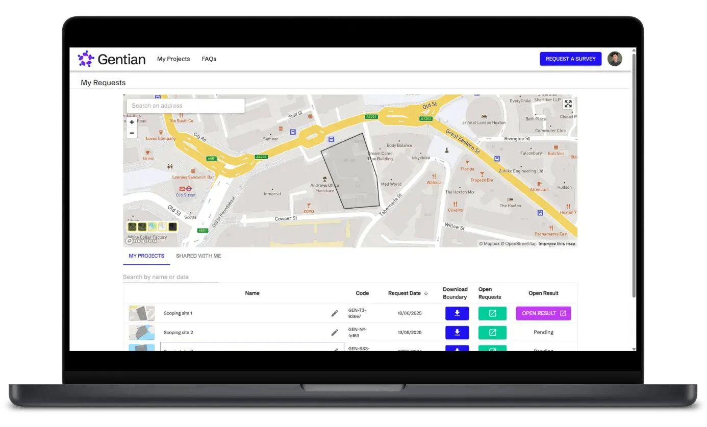
For Gentian True Sight, the process is fully automated through our online platform. Simply upload a shapefile or draw the boundary of the area you want mapped, select your service, and upon payment, receive your results in as little as five minutes. For Gentian True Sage, Gentian True Oracle, and Gentian True Urban, please contact us, and a member of our team will reach out to discuss your specific requirements and guide you through the process.
Use-cases & applications
How can Gentian support Biodiversity Net Gain (BNG)?
Gentian provides AI-powered habitat classification aligned with BNG statutory metrics for baseline assessments (Gentian True Sight & Gentian True Sage) and offers long-term biodiversity monitoring to track uplift and ensure compliance (Gentian True Sage).
How does Gentian support TNFD and CSRD reporting?
Gentian provides high-resolution biodiversity risk assessments aligned with TNFD & CSRD compliance frameworks (Gentian True Sage). Our habitat mapping satisfies requirements to map land cover and land use change. Additionally, we provide connectivity analysis and proximity to key biodiversity areas (KBA). Our data enables corporations to quantify their impact on nature, assess biodiversity-related risks associated with their operations, and identify opportunities for ecological uplift on their land.
Can Gentian assist with carbon reporting?
Yes. Gentian’s solutions primarily estimate changes in carbon storage resulting from habitat or land-use change, providing valuable insights for corporate climate strategies and nature-based carbon offsetting. While a baseline map alone offers limited information on carbon storage or sequestration—often assuming a carbon-neutral state—our data enables organisations to assess the impact of land-use transitions on carbon dynamics. Contact us to find out more.
How can Gentian support local authorities?
Gentian helps local authorities enhance urban biodiversity and climate resilience by providing AI-powered mapping for tree canopy assessments, identifying green roof and biosolar opportunities, and analysing flood risk and permeable surface coverage to support sustainable planning (Gentian True Urban).
Can Gentian provide historical biodiversity data?
Yes. Our platform can analyse past satellite and aerial imagery to generate historical biodiversity baselines and track land-use changes over time. While data availability may vary for imagery before 2016, we can assess options based on your specific needs. Please contact us to learn more.
Do you operate internationally?
Yes, Gentian provides global habitat mapping services, supporting biodiversity monitoring and environmental compliance across multiple regions. Our projects span the UK, France, the United States, Canada, Japan, and beyond, with the capability to deliver high-resolution ecological insights anywhere in the world.
Technology & methodology
How does Gentian’s technology work?
Gentian combines advanced AI, remote sensing, and high-resolution satellite imagery to map and monitor habitats with exceptional accuracy. Our proprietary machine learning models classify habitats according to recognised ecological frameworks, providing scalable and reliable biodiversity insights.
How accurate is Gentian’s habitat mapping?
Our AI models are trained on high-resolution imagery (<50 cm) and extensive ground-truth data to ensure precision. Our data undergoes rigorous quality assurance, including expert ecological review, to deliver scientifically robust and actionable insights.
Can Gentian replace traditional ecological surveys?
Not in general. Gentian complements traditional surveys by providing scalable, remote assessments. Our solutions can help ecologists prioritise on-the-ground work by reducing manual survey time and increasing coverage.
How does Gentian’s technology compare to traditional ecological surveys?
Unlike manual surveys, which can be time-consuming and resource-intensive, Gentian provides rapid, scalable, and cost-effective habitat mapping across large areas. We believe our technology complements traditional fieldwork, and offers a consistent, remote-first approach that reduces reliance on site visits and improves long-term monitoring.
How often is Gentian’s habitat data updated?
The frequency of updates depends on the project and the available satellite imagery. We prioritise the most recent high-resolution data, with our advanced models enabling year-over-year comparisons to monitor habitat changes over time.
Pricing & implementation
How is Gentian’s pricing structured?
Gentian’s pricing is determined by the product selected, the size of the geographical area being mapped, and whether the data is required as a one-time analysis or for continuous monitoring. For Gentian True Sight assessments can be priced and purchased directly on our online platform. For a tailored quote for all other products, please get in touch with our team.
Does Gentian offer subscription-based access?
Yes. We provide annual and on-demand subscriptions for continuous biodiversity monitoring. Please contact us for further information.
Can Gentian’s data be integrated into my existing GIS or reporting system?
Yes. Our habitat mapping data is delivered in standardised formats, including GeoJSON, shapefiles, and raster datasets, ensuring seamless integration with GIS platforms and compliance reporting tools such as TNFD, CSRD, and biodiversity net gain (BNG) frameworks. Additionally, we provide summary statistics in spreadsheet format (CSV) and high-quality PDF maps, making it easy to incorporate insights directly into reports.
Do you offer an API?
Yes, Gentian provides an API that allows seamless integration of our habitat mapping and biodiversity data into your existing workflows, enabling automated access to high-resolution ecological insights. Contact us to learn more about API access and implementation.
How quickly can I receive habitat mapping results?
For Gentian True Sight, results are delivered in as little as five minutes through our automated online platform. For Gentian True Sage, habitat mapping is completed within 10 working days. If you require a customised solution with Gentian True Oracle or Gentian True Urban, please contact us to discuss your specific timeline.
Explore our products

Gentian True Sight
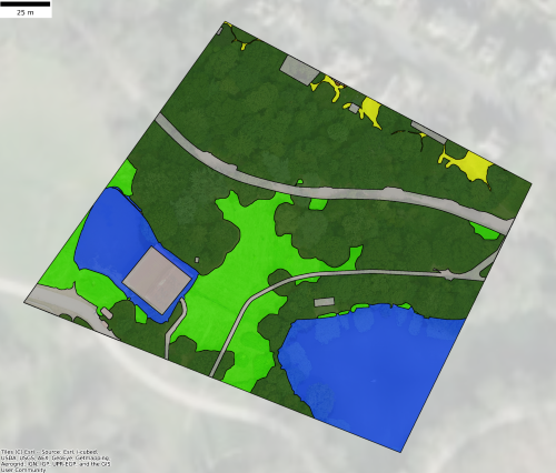
Gentian True Sight delivers rapid, AI-powered habitat classifications that are fully compatible with the biodiversity net gain (BNG) metric, providing instant habitat insights for rapid decision-making and site-scoping—fully remote, available within minutes and scalable across multiple sites.
.png?width=952&height=671&name=unnamed%20(4).png)
Gentian True Sage
Gentian True Sage delivers precise, AI-powered biodiversity assessments, enabling organisations to map habitats, track ecological changes, and meet compliance needs with unparalleled accuracy and efficiency—fully remote, at speed, and with none of the scalability issues associated with traditional methods.
_11zon.webp?width=1173&height=1058&name=Untitled%20design%20(3)_11zon.webp)
Gentian True Oracle
Gentian True Oracle is our enterprise-level solution, offering bespoke AI-powered biodiversity insights. Designed for R&D, it enables custom feature development to meet the unique data needs of organisations tackling complex environmental challenges.
.png?width=2048&height=690&name=unnamed%20(2).png)
Gentian True Urban
Gentian True Urban delivers high-resolution biodiversity and climate resilience insights for towns and cities. Using AI-powered analysis, it maps green spaces, tracks urban habitat change, and supports sustainable planning with precision data.
Contact us
Whether you’re scoping a site, shaping a sustainability strategy, or monitoring long-term change, we’re here to help. Let’s explore how Gentian’s tools can support your environmental goals with speed, accuracy, and clarity.