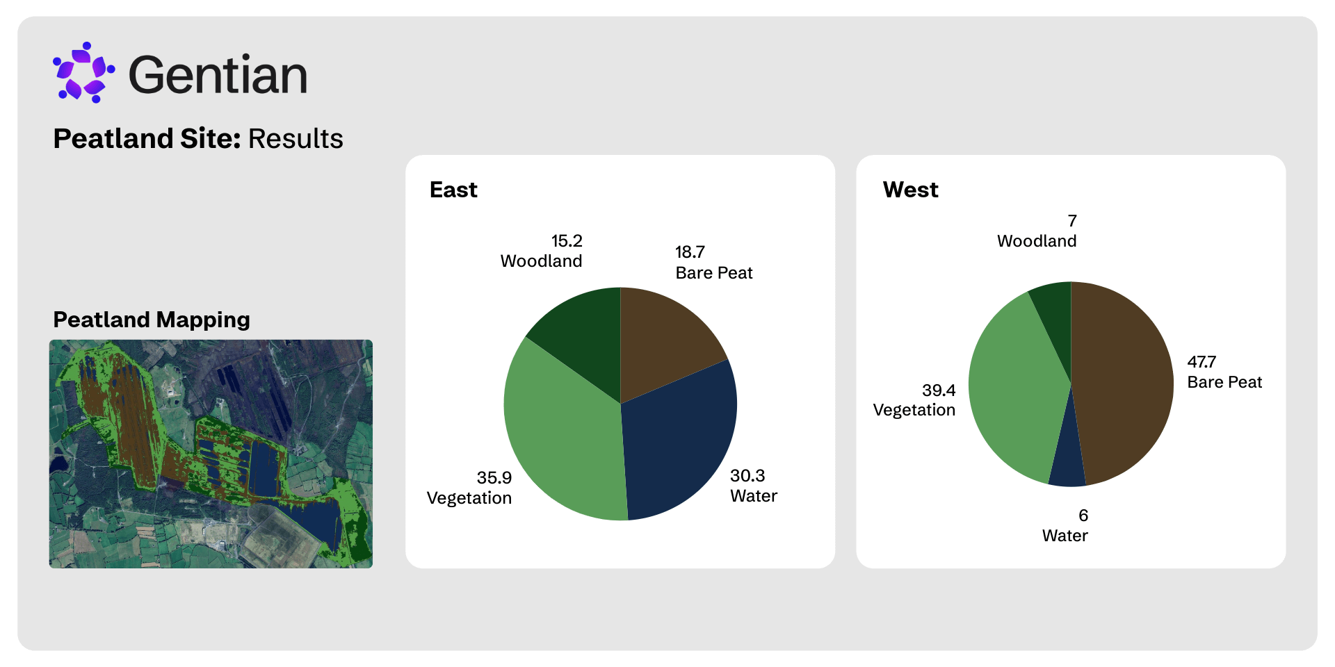
Peatland Mapping
Gentian delivers scalable, AI-powered peatland mapping using high-resolution satellite imagery and ecological expertise. We detect habitat type, assess condition, and monitor restoration progress, remotely and at scale.
.jpg?width=2000&height=1333&name=george-hiles-bmGmO5EeRvc-unsplash%20(1).jpg)
How does our peatland mapping work?
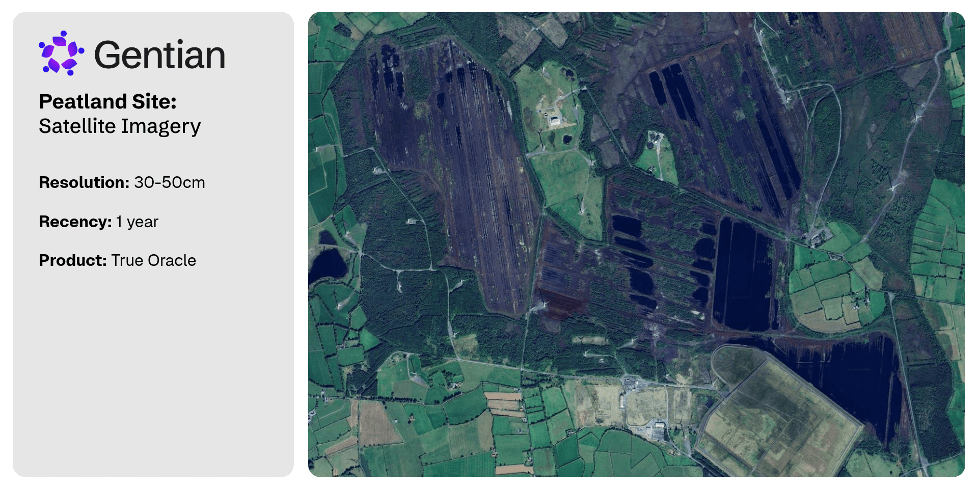
Using satellite imagery as fine as 50 cm, we apply custom-trained AI models to classify peatland extent, identify habitat variation, and track ecosystem change.
We can monitor features such as dry vs wet peat, invasive tree encroachment (e.g. Sitka spruce), vegetation type (mosses, sedges, bog woodland), and structural patterns like pools or peat cuttings.
Define your area
Provide site boundaries or regions of interest.
Custom analysis
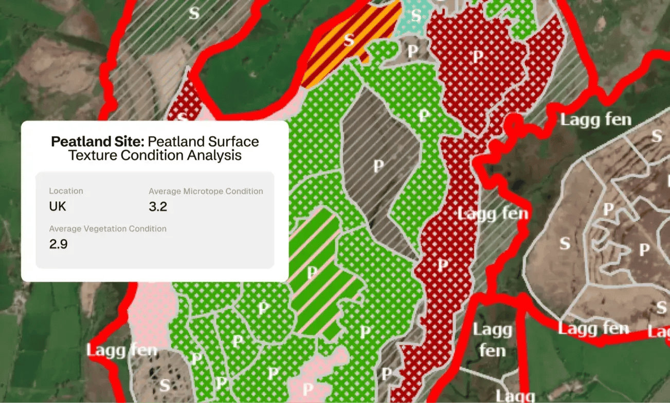
We apply peatland condition matrices (PCM), microtopography mapping, and spectral analysis to assess extent and health.
.png?width=1920&height=960&name=Services%20Pages%20Graphics-2%20(2).png)
Actionable outputs
Receive clear maps and data visualisations, compatible with the Peatland Code, biodiversity metrics, and restoration planning.
Why is peatland mapping important?
Peatland mapping refers to the remote sensing and classification of peatland ecosystems. It includes delineating peatland extent, categorising habitat types, and assessing condition indicators like vegetation cover, microtopography, and moisture levels.
Peatlands store twice as much carbon than all the world’s forests combined. When healthy, they regulate water, support biodiversity, and provide critical ecosystem services. When degraded, they become major carbon sources.
Monitoring peatland condition is essential to climate, biodiversity, and land management goals.
.jpg?width=1700&height=1133&name=transly-translation-agency-Gk7ZOxI2U2U-unsplash%20(1).jpg)
How is peatland mapping conducted?
Peatland mapping combines on-the-ground surveys with satellite-based remote sensing. Field methods include peat core sampling, vegetation surveys, and hydrological monitoring to validate condition. Traditional mapping helps define site boundaries and habitat types.
Gentian enhances this with sub-50 cm satellite imagery and AI, detecting vegetation structure, water levels, and invasive species. This approach enables fast, consistent mapping across large or remote peatland areas.
.jpg?width=1300&height=975&name=henry-schneider-ifZEJE1_vI0-unsplash%20(1).jpg)
Key aspects of peatland mapping
Peatland mapping focuses on identifying and assessing the extent, type, and condition of peatland habitats. Key aspects include:
-
Extent Mapping – Defining the boundaries of peatland areas using imagery and ecological indicators.
-
Habitat Classification – Distinguishing between peatland types (e.g. bog, fen) and associated vegetation communities.
-
Condition Assessment – Evaluating indicators like vegetation cover, water levels, bare peat, erosion, and tree encroachment.
-
Change Detection – Monitoring restoration progress or degradation over time through repeat assessments.
-
Integration with Standards – Aligning outputs with frameworks like the Peatland Code, TNFD, or biodiversity credit schemes.
What does a peatland condition assessment involve?
A peatland condition assessment evaluates the health and functionality of a peatland ecosystem. It typically involves measuring indicators such as vegetation composition, water saturation levels, presence of bare peat or erosion, and signs of disturbance like tree encroachment or drainage.Gentian’s assessments use satellite imagery, spectral analysis, and AI to remotely evaluate these features. We also apply the Peatland Condition Matrix (PCM) to classify condition levels, supporting restoration planning, carbon credit eligibility, and long-term monitoring.
.jpg?width=2000&height=1333&name=ulrich-knoll-1wbbEnfXRqA-unsplash%20(1).jpg)
Why choose Gentian?
Gentian combines deep expertise in ecology and AI with experience mapping peatlands across the UK, Ireland, and North America. We are actively developing the UK’s most advanced remote peatland condition monitoring system.
Our approach incorporates the Peatland Condition Matrix (PCM), field-validated datasets, and machine learning workflows tailored for peatland features. We help restoration bodies, certifiers, and land managers get credible, science-based data, quickly and cost-effectively.
.jpg?width=2000&height=1333&name=k8-glEq5uPpBQs-unsplash%20(1).jpg)

Cost-efficient & scalable
Eliminates the need for expensive, manual field surveys.

Rapid delivery
Assessments completed in days or even minutes, not weeks or months.

Unparalleled accuracy
Sub-meter resolution satellite imagery for precise habitat mapping.
.png?width=100&height=100&name=icons8-trust-100%20(1).png)
Trusted data
Reports fully aligned with statutory metrics and checked by our in-house ecological experts for quality.
.png?width=1540&height=558&name=GFSA_DigitalBadge_withoutyear_2024%20(1).png)


.jpg?width=1800&height=1200&name=joel-holland-TRhGEGdw-YY-unsplash%20(1).jpg)
Ecological Surveys
Gentian delivers high-resolution, AI-powered ecological surveys that are faster, more scalable, and cost-effective—offering reliable insights to support planning, land management, and sustainability goals.
.jpg?width=1600&height=1067&name=claudel-rheault-ZVbv1akA-l4-unsplash%20(1).jpg)
Habitat Mapping
Gentian uses AI and satellite imagery to map habitats with speed and accuracy. Ideal for baselines, monitoring, or biodiversity risk insights—giving you a clear view of the landscape.

Biodiversity Monitoring, Reporting and Verification (MRV)
Our AI-powered MRV solutions deliver accurate, remote assessments of habitat change and ecological condition over time, aligned with TNFD, CSRD, and other global standards.
Phase 1 Habitat Surveys
Gentian delivers remote Phase 1 Habitat Surveys using AI and high-resolution satellite imagery—providing rapid, cost-effective alternatives to traditional field-based assessments, whether for early-stage scoping, risk screening, or desktop baselines.