Biodiversity Net Gain (BNG) Assessments
Gentian’s Biodiversity Net Gain (BNG) Assessments use advanced AI and high-resolution satellite imagery to deliver fast, accurate habitat surveys for site scoping and selection. Our reliable and scalable remote assessments help you plan and prioritise biodiversity actions with confidence.

How our BNG Assessments work
Gentian uses high-resolution satellite imagery and advanced AI to deliver fast, remote BNG assessments at scale.
Our outputs align with Biodiversity Net Gain (BNG) statutory metrics, enabling accurate baseline assessments and early identification of ecological constraints. This supports feasibility screening, site selection, and risk management from the outset.
Delivered in days or even minutes, and not weeks, our approach eliminates the seasonal delays, logistical barriers, and costs associated with traditional surveys, making biodiversity assessment faster, simpler, and more scalable.
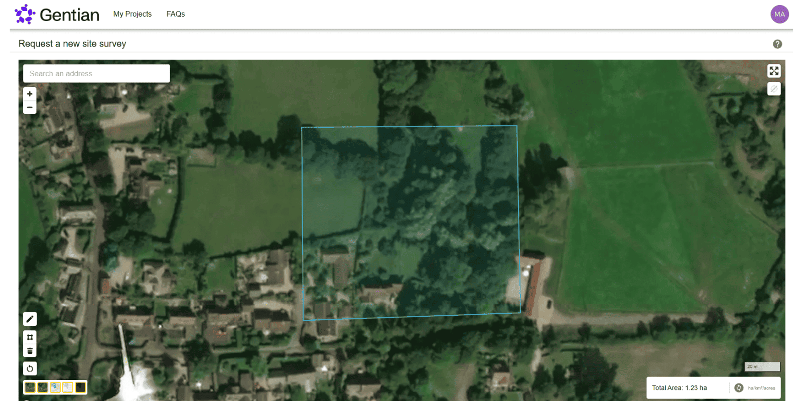
Submit your site boundary
Use our intuitive online platform to define the precise location and area of your assessment.
Wait for your satellite-based assessment
Completed remotely within minutes to days, utilising our advanced AI and expert guidance (for premium solutions).
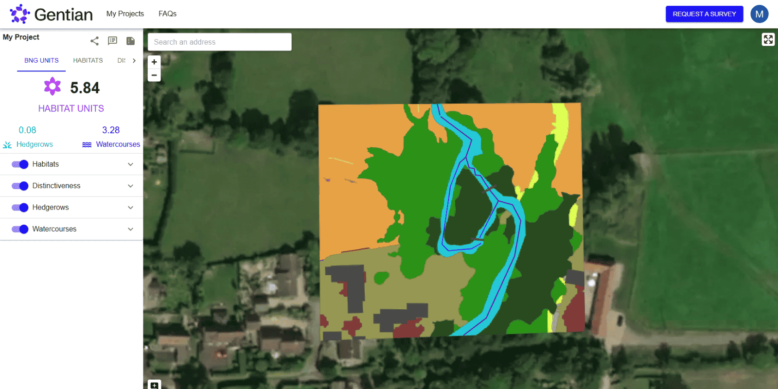
Receive comprehensive, compliant reports
Highlighting habitat types, conditions, calculated biodiversity units, and more.

How does Biodiversity Net Gain work?
Biodiversity Net Gain (BNG) is a mandatory approach to development and land management in England that aims to leave the natural environment in a measurably better state than it was before.
Put simply, BNG ensures developments such as housing estates achieve at least a 10% increase in biodiversity. Using habitat surveys, biodiversity metrics are calculated pre- and post-development to demonstrate net gains.

What is a Biodiversity Net Gain plan?
A Biodiversity Net Gain Plan outlines how a project will deliver and maintain biodiversity improvements, detailing pre-development habitat baselines and post-development commitments. It includes specific actions, management strategies, and monitoring plans to ensure long-term biodiversity enhancements, meeting regulatory requirements and contributing positively to local ecosystems.

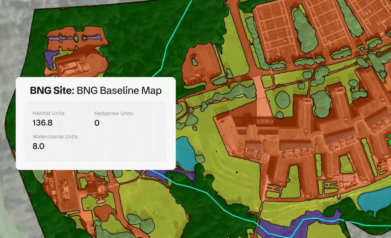
Biodiversity Net Gain Assessment Report
A BNG Assessment Report provides detailed insights into existing habitat types, conditions, and biodiversity units calculated in line with statutory biodiversity metrics, guiding developers and planners toward positive ecological outcomes. The report includes clear visual maps of habitats, precise biodiversity metrics, and strategic recommendations for enhancing ecological value.
Biodiversity Net Gain Laws and Regulations
Under the UK's Environment Act 2021, a minimum 10% BNG is required for most new developments. While Gentian’s assessments are not designed to fulfil BNG compliance directly, they provide calculated biodiversity units that help scope out sites, inform site selection, and de-risk site acquisition. Our rapid, remote surveys enable developers to make smarter, nature-positive decisions earlier in the project lifecycle.

Why choose Gentian?
Gentian combines ecological expertise, advanced AI, and remote sensing to provide the clarity and data you need to make nature-positive decisions earlier, faster, and more cost-effectively than traditional surveys.
.jpg?width=2000&height=1333&name=k8-glEq5uPpBQs-unsplash%20(1).jpg)

Cost-Efficient & Scalable
Eliminates the need for expensive, manual field surveys.

Rapid Delivery
Assessments completed in days or even minutes, not weeks or months.

Unparalleled Accuracy
Sub-meter resolution satellite imagery for precise habitat mapping.
.png?width=100&height=100&name=icons8-trust-100%20(1).png)
Trusted Data
Reports fully aligned with statutory metrics and checked by our in-house ecological experts for quality.
Rapid biodiversity insights enable facilities management leader to cut site scoping times significantly
A leading UK facilities management company needed faster, scalable biodiversity assessments. Using Gentian True Sight, they cut site-scoping time, reduced costs, and improved proposals, securing projects over competitors.

.png?width=1540&height=558&name=GFSA_DigitalBadge_withoutyear_2024%20(1).png)


.jpg?width=1800&height=1200&name=joel-holland-TRhGEGdw-YY-unsplash%20(1).jpg)
Ecological Surveys
Gentian delivers high-resolution, AI-powered ecological surveys that are faster, more scalable, and cost-effective—offering reliable insights to support planning, land management, and sustainability goals.
.jpg?width=1600&height=1067&name=claudel-rheault-ZVbv1akA-l4-unsplash%20(1).jpg)
Habitat Mapping
Gentian uses AI and satellite imagery to map habitats with speed and accuracy. Ideal for baselines, monitoring, or biodiversity risk insights—giving you a clear view of the landscape.
Biodiversity Monitoring, Reporting and Verification (MRV)
Our AI-powered MRV solutions deliver accurate, remote assessments of habitat change and ecological condition over time, aligned with TNFD, CSRD, and other global standards.

Phase 1 Habitat Surveys
Gentian delivers remote Phase 1 Habitat Surveys using AI and high-resolution satellite imagery—providing rapid, cost-effective alternatives to traditional field-based assessments, whether for early-stage scoping, risk screening, or desktop baselines.