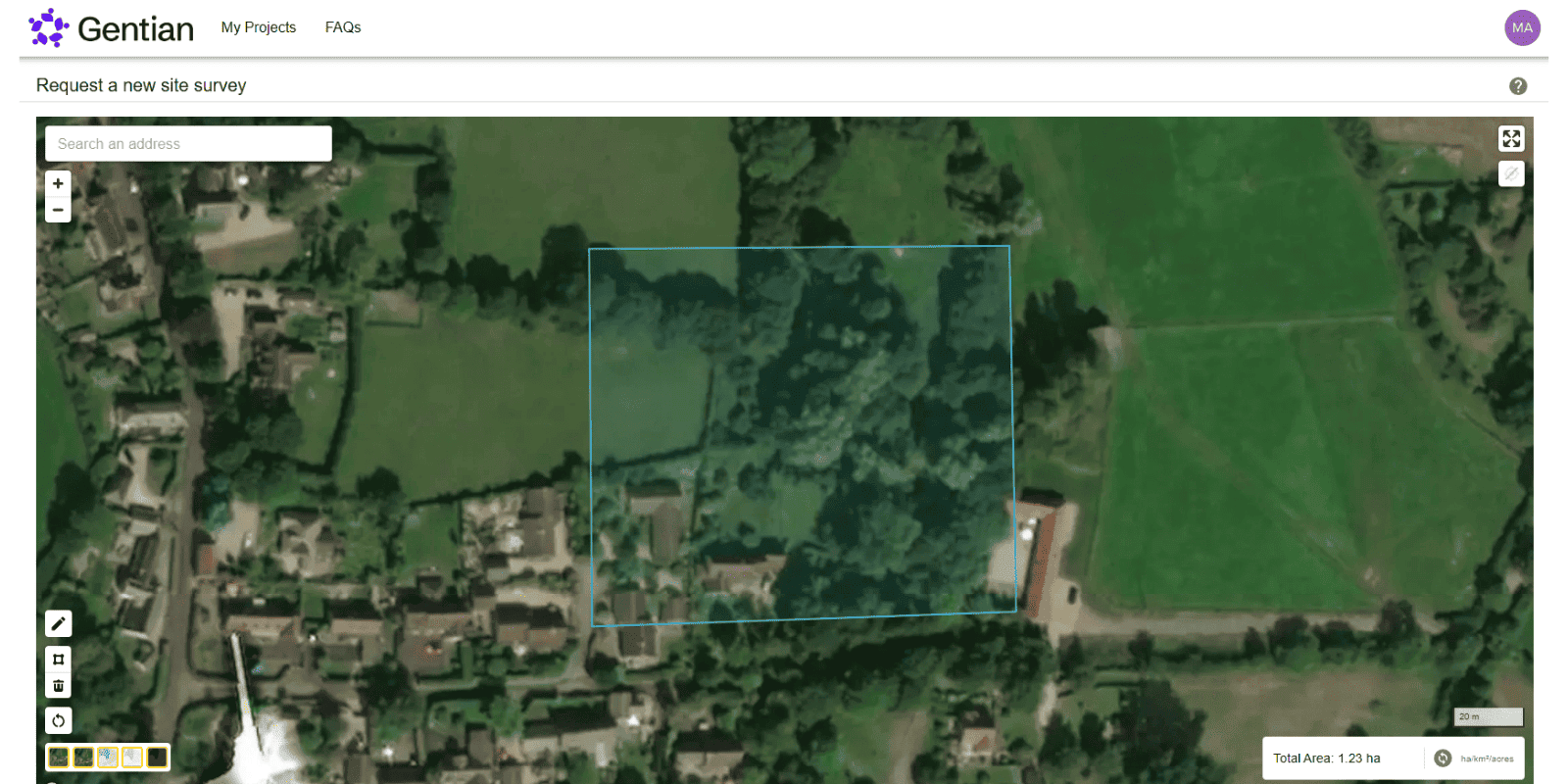
Biodiversity Monitoring, Reporting and Verification (MRV)
Gentian enables organisations to track biodiversity outcomes with clarity and confidence. Our AI-powered MRV solutions deliver accurate, remote assessments of habitat change and ecological condition over time, aligned with TNFD, CSRD, and other global standards.
.jpg?width=5184&height=3456&name=serge-taeymans-YF5qsT8euC0-unsplash%20(1).jpg)
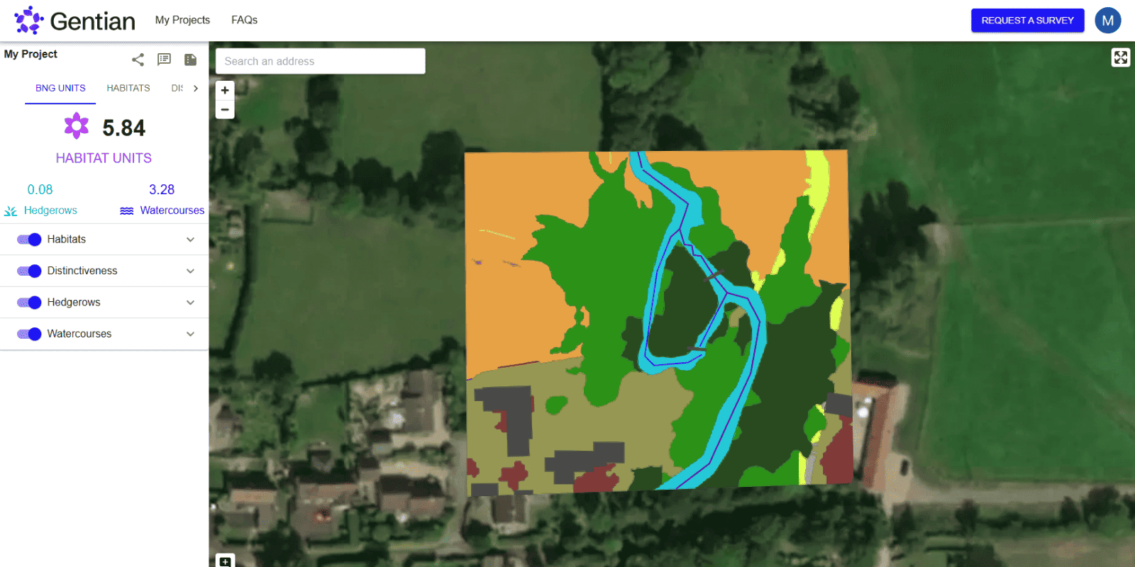
How Biodiversity Monitoring, Reporting and Verification (MRV) works
Gentian's MRV services combine high-resolution satellite imagery, AI classification, and expert ecology input to quantify and monitor biodiversity performance at scale.
Our platform can detect habitat type, measure change, estimate condition, and provide consistent outputs year-on-year.
Our data is designed to support regulatory disclosures such as TNFD and supports habitat classification schemes like UKHab, EUNIS, and IUCN, ensuring flexibility and global relevance.
-1.png?width=1570&height=1200&name=True%20Sage%20Graphic%20Two%20(3)-1.png)
Define your sites
Submit shapefiles or draw boundaries for one or multiple locations.
Baseline and monitor
We map habitat extent, quality, and change over time, or more, depending on your requirements.
Verify and report
Receive repeatable, customised reports aligned with your ESG frameworks and external disclosures.

What is Biodiversity MRV?
Monitoring, Reporting and Verification (MRV) refers to the systematic process of measuring environmental impacts over time. In the context of biodiversity, MRV allows organisations to:
- Establish baselines for habitat type and condition
- Monitor changes in land cover and ecosystem quality
- Report consistently to regulators, investors, or the public
- Verify claims of ecological uplift or mitigation
.jpg?width=2200&height=1467&name=kapturedbykasia-0bhhVEDAs14-unsplash%20(1).jpg)
.jpg?width=3766&height=2509&name=lance-anderson-QZwf5yNopUo-unsplash%20(1).jpg)
What have been the challenges of MRV?
Historically, biodiversity MRV has faced barriers including fragmented data sources, lack of repeatability, and high costs of field-based monitoring. Aligning methods across sites and frameworks has also been difficult. Gentian addresses these challenges by offering remote, scalable, and standardised solutions built for global use.

What are the benefits of MRV?
MRV builds trust and transparency by offering objective evidence of biodiversity performance. It enables organisations to benchmark progress, access finance linked to environmental outcomes, and confidently disclose their impact to stakeholders. With consistent data and automated reporting, MRV also reduces the administrative burden of manual assessments.
-1.jpg?width=2400&height=1600&name=thomas-bormans-ZtM-W-3f0C4-unsplash%20(1)-1.jpg)
Why choose Gentian?
Gentian provides a biodiversity MRV solution that balances ecological rigour with commercial flexibility. We bring together our ecological expert backed data with user-focused delivery, enabling both technical teams and executive stakeholders to access and act on robust biodiversity insights. Our platform supports everything from early-stage baselining to long-term impact verification, making it suitable for sustainability reporting, biodiversity credit validation, and conservation programme evaluation alike.


Globally scalable
Apply biodiversity MRV across sites around the world.

Fully remote
No fieldwork delays or seasonal constraints.
.png?width=96&height=96&name=icons8-pass-96%20(1).png)
Aligned with frameworks
Output formats compatible with TNFD, SBNTN, and CSRD.
.png?width=100&height=100&name=icons8-trust-100%20(1).png)
Trusted expertise
Data reviewed by ecologists and GIS analysts.
.png?width=1540&height=558&name=GFSA_DigitalBadge_withoutyear_2024%20(1).png)


.jpg?width=1800&height=1200&name=paul-summers-ArtVJ-217Cw-unsplash%20(1).jpg)
ESG Reporting
Gentian helps organisations integrate nature-related data into ESG reporting. Our AI-powered platform delivers expert-checked biodiversity and habitat insights aligned with evolving disclosure standards, including TNFD and CSRD.
.jpg?width=1600&height=1067&name=claudel-rheault-ZVbv1akA-l4-unsplash%20(1).jpg)
Habitat Mapping
Gentian uses AI and satellite imagery to map habitats with speed and accuracy. Ideal for baselines, monitoring, or biodiversity risk insights—giving you a clear view of the landscape.
Biodiversity Monitoring, Reporting and Verification (MRV)
Our AI-powered MRV solutions deliver accurate, remote assessments of habitat change and ecological condition over time, aligned with TNFD, CSRD, and other global standards.
.jpg?width=1200&height=900&name=nathan-queloz-uH6aUN38ep8-unsplash%20(1).jpg)
TNFD Reporting
Gentian helps organisations prepare for nature-related disclosures with AI-powered biodiversity data aligned to the TNFD framework. Our remote platform delivers high-resolution, structured insights that support each stage of the LEAP process.