Ecological Surveys
Gentian delivers Very-High-Resolution, AI-driven ecological surveys that are instantly scalable—eliminating the bottlenecks of traditional fieldwork. Whether planning development, quantifying natural capital, or managing asset portfolios, our remote insights deliver the precision and risk clarity you need to act.
.jpg?width=6016&height=4000&name=henry-perks-WOUCHo4zlDg-unsplash%20(1).jpg)
How our ecological surveys work
Gentian delivers rapid, remote ecological surveys leveraging sub-50 cm satellite imagery and proprietary AI. We classify ecosystems and quantify ecological shifts—eliminating the bottlenecks of seasonal fieldwork.
We engineer proprietary AI models to classify a vast spectrum of land cover and habitat indicators. This ensures precise ecology data across complex urban, utility, and natural landscapes.
Whether performing due diligence, monitoring global portfolios, or accelerating ESG and TNFD goals, our ecology surveys deliver scalable precision to empower resilient decision-making.
.jpg?width=2000&height=1333&name=marc-pell-oWRVjFQIwAY-unsplash%20(1).jpg)
Submit your site boundary
Upload site boundaries or shapefiles via our platform to map your area of interest.
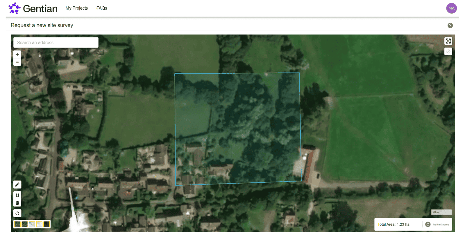
Wait for your satellite-based survey
Analysis completed remotely in minutes—leveraging proprietary AI and expert verification.
Receive expert-reviewed reports
Receive verified reports including risk metrics, precision habitat maps, and TNFD-aligned baselines.

How do ecological surveys work?
Ecological surveying assesses the habitats and species present on a site to support due diligence, risk mitigation, and strategic land management. The process begins with a desktop study, leveraging aerial data to establish context. Ecologists then visit sites to map habitats, assess habitat condition, and identify any protected species. Findings are synthesized into actionable data—featuring maps, metrics, and strategies for mitigation or climate resilience.
.jpg?width=2200&height=1650&name=neil-macc-COcF_5cewN0-unsplash%20(1).jpg)
How does Gentian differ?
Eliminating the bottlenecks of manual fieldwork, our platform delivers precise ecology data remotely. Leveraging sub-50 cm satellite imagery—processed by AI and rigorously verified by experts ecologists—we empower you to:
- Gain faster results
- Slash overheads
- Enable early-stage decision-making
- Unlock scalable assessments across large areas
.jpg?width=3456&height=2304&name=tania-malrechauffe-uajvdr609Rs-unsplash%20(1).jpg)
Why choose Gentian?
By leveraging sub-50 cm satellite imagery, AI-driven analytics, and rigorous expert verification, we unlock actionable data —empowering strategic decisions across resilient planning, asset management, and risk mitigation.
.jpg?width=1200&height=900&name=aaron-brunhofer-SwwoxDZrW5I-unsplash%20(1).jpg)

Speed
Ecology data delivered in days or minutes—eliminating the bottlenecks of manual fieldwork.

Coverage
Survey assets anywhere, from single plots to national portfolios.

Accuracy
Leveraging sub-50 cm imagery and proprietary AI for granular risk modeling.
.png?width=100&height=100&name=icons8-trust-100%20(1).png)
Insight
Data rigorously verified by in-house experts for TNFD alignment and investor confidence.
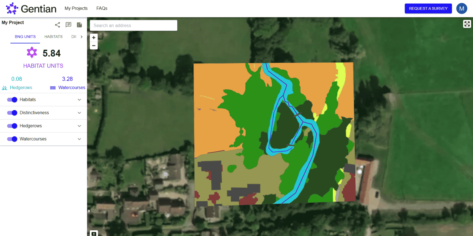
Landowner transforms its biodiversity monitoring, demonstrating measurable net gains across 50+ Sites
A major operator leveraged Gentian True Sight to map 50+ sites in 90 days, quantifying measurable ecological value. The platform slashed overheads, streamlined reporting, and ensured scalable, evidence-based tracking.

.png?width=1540&height=558&name=GFSA_DigitalBadge_withoutyear_2024%20(1).png)


Biodiversity Net Gain (BNG) Assessments
Gentian’s biodiversity assessments leverage advanced AI and sub-50cm imagery to deliver rapid, precise habitat surveys for due diligence and site selection.

Biodiversity Monitoring, Reporting and Verification (MRV)
Our AI-driven MRV platform delivers precision remote assessments of habitat change and risk trends over time—fully aligned with TNFD, CSRD, and global standards.
.jpg?width=1600&height=1067&name=claudel-rheault-ZVbv1akA-l4-unsplash%20(1).jpg)
Habitat Mapping
Gentian leverages AI and satellite imagery to deliver rapid, precision ecology data. Ideal for baselines, resilience monitoring, or risk modeling—giving you a clear strategic view.