Remote Tree Surveys
Gentian delivers rapid tree surveys using sub-50 cm satellite imagery and AI-driven environmental data. We empower landowners, developers, and asset managers to map canopy cover and estimate tree counts at scale—eliminating the need for boots on the ground.

How our tree surveys work
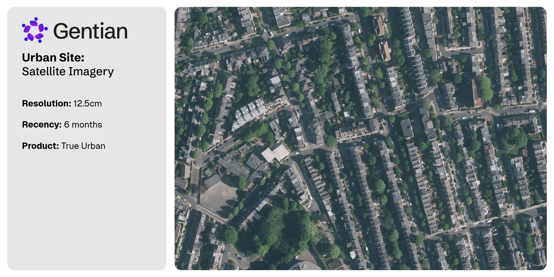
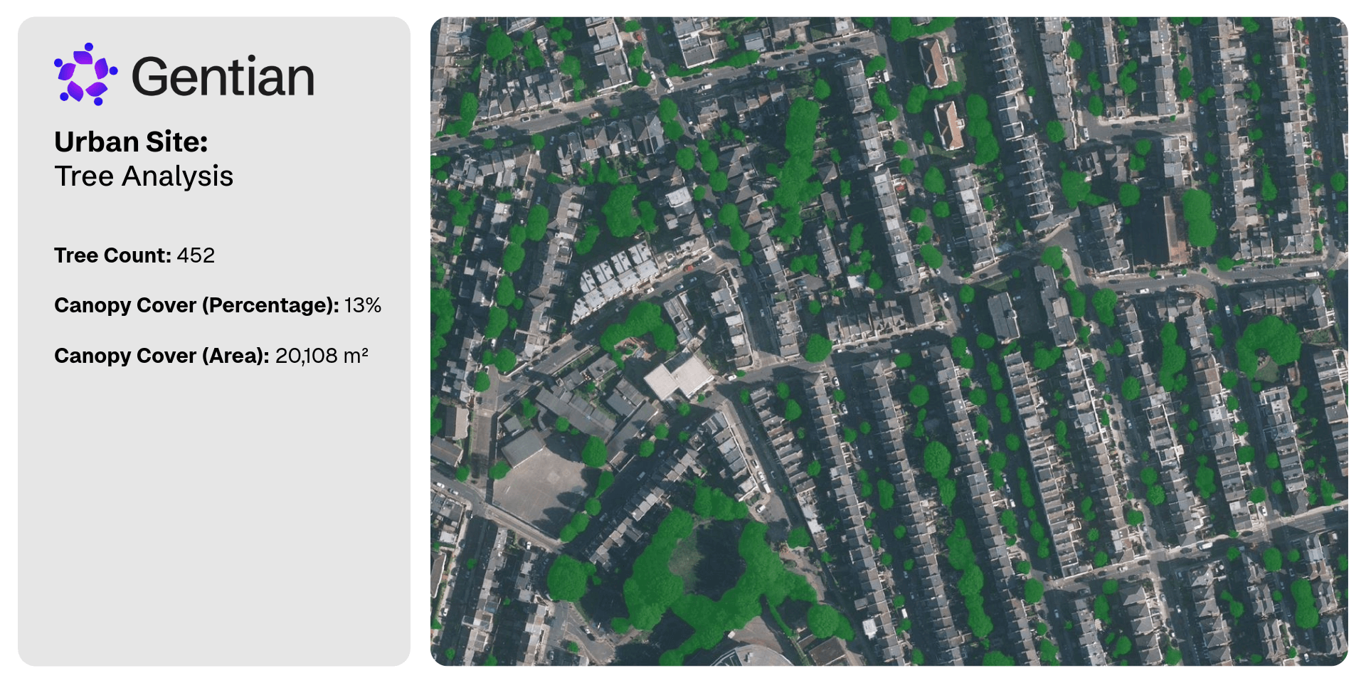
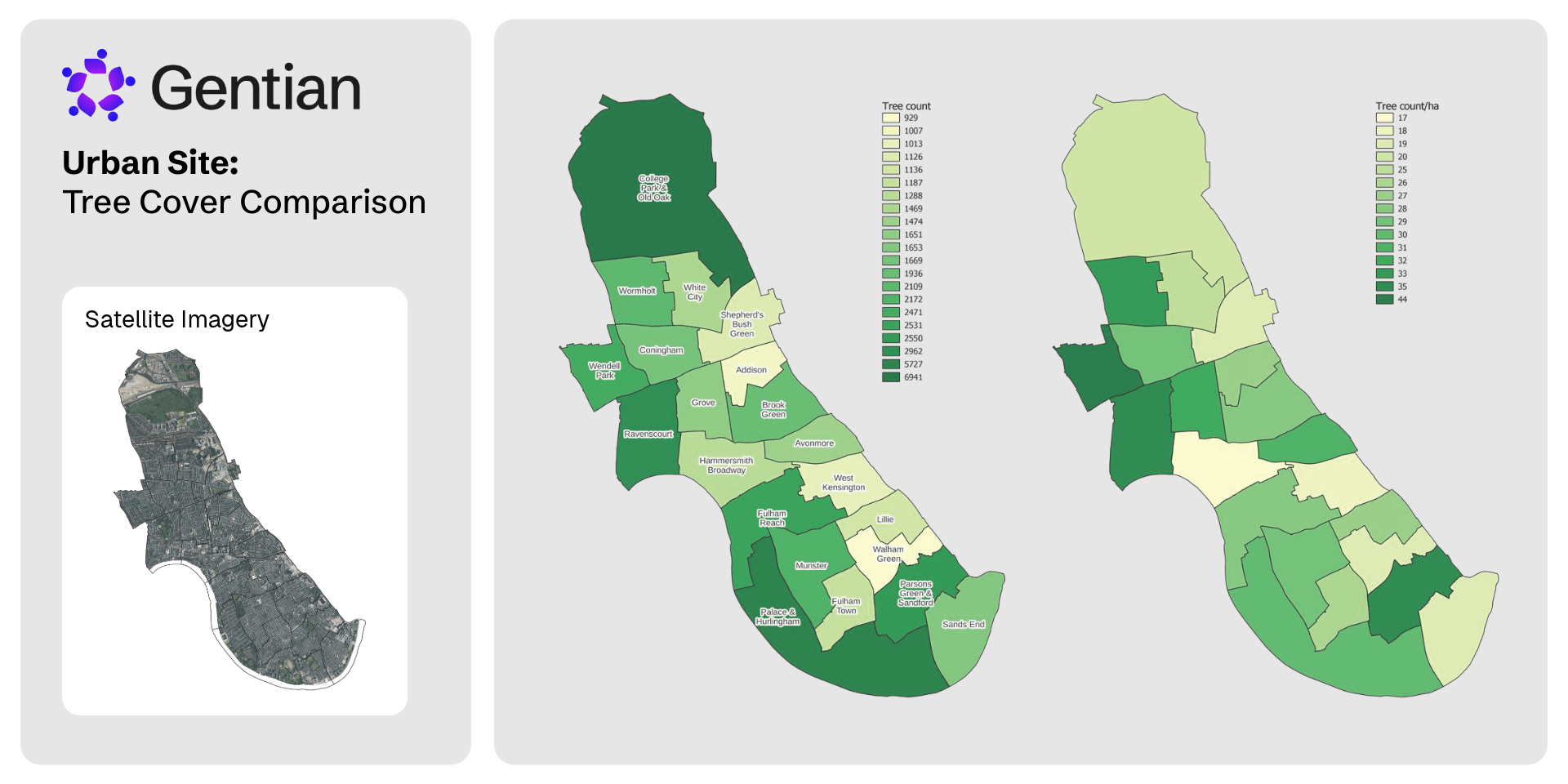
Gentian leverages sub-50 cm satellite imagery and proprietary AI to deliver rapid, tree risk surveys with precision. We map canopy cover and estimate tree counts across urban, rural, and natural landscapes.
Our models identify individual tree features where resolution allows, and generates granular spatial outputs for planning, risk modeling, and green infrastructure strategies.
Engineered for scale, our data accelerates ESG reporting and TNFD alignment—empowering organizations to quantify, manage, and disclose tree assets with confidence.
%20(1).png?width=1024&height=768&name=Untitled%20(6)%20(1).png)
Define your area
Upload or draw your site boundary via our platform.
Remote sensing and analysis
Our models estimate tree counts and map canopy cover with precision.
Unlock actionable data
Receive GIS-compatible datasets and structured reports ready for analysis.
What is a tree survey for?
Accurate tree surveys underpin strategic planning, development, and risk mitigation. These surveys quantify the extent of canopy assets, assesses material risks, and drives alignment with climate resilience and green infrastructure goals.
Gentian’s remote environmental data is engineered for accelerating due diligence, establishing risk baselines, and optimizing ESG and TNFD disclosures.
.jpg?width=1000&height=605&name=jan-huber-4OhFZSAT3sw-unsplash%20(1).jpg)
Why is a tree survey important for biodiversity?
Trees represent critical green infrastructure underpinning climate resilience. They drive ecological connectivity, regulate microclimates, and secure soil and water health—functioning as the backbone of resilient ecosystems.
Tree surveys quantify these natural assets. By tracking distribution, canopy cover, and changes over time, asset managers and developers drive data-backed decisions to mitigate risk and optimize ecological value.
How Gentian can help with your tree survey report
Gentian delivers rapid, tree risk surveys leveraging sub-50 cm satellite imagery and proprietary AI. We deliver precise data on tree counts and canopy cover—eliminating the bottlenecks of manual fieldwork.
Our outputs include GIS-ready files and structured datasets, seamlessly slotting into planning workflows and ESG disclosures. Whether assessing a single site or a national portfolio, we empower you to unlock actionable tree data—instantly and at scale.
.jpg?width=700&height=467&name=mike-benna-SBiVq9eWEtQ-unsplash%20(1).jpg)
Why choose Gentian?
Gentian leverages advanced satellite imagery and proprietary AI to deliver precise tree surveys—accelerating timelines from months to days. Our platform eliminates the bottlenecks of manual fieldwork, delivering the actionable nature-related data required for strategic decisions.
We ensure scalable coverage across any landscape, with outputs engineered for ESG reporting, TNFD alignment, and green infrastructure strategies. With verified data and expert support, Gentian is the trusted partner for rapid, enterprise-grade environmental data.
.jpg?width=2000&height=1333&name=k8-glEq5uPpBQs-unsplash%20(1).jpg)

Cost-efficient & scalable
Eliminates the bottlenecks of expensive, manual field surveys.

Rapid delivery
Nature data delivered in days or minutes—accelerating decision cycles.

Unparalleled accuracy
Sub-meter resolution satellite imagery for granular habitat mapping.
.png?width=100&height=100&name=icons8-trust-100%20(1).png)
Trusted data
Reports fully aligned with TNFD and global standards, rigorously verified by our in-house experts.
.png?width=1540&height=558&name=GFSA_DigitalBadge_withoutyear_2024%20(1).png)


.jpg?width=1800&height=1200&name=joel-holland-TRhGEGdw-YY-unsplash%20(1).jpg)
Ecological Surveys
Gentian delivers high-resolution, AI-driven ecological data that is instantly scalable and reduces overhead—offering actionable insights to accelerate planning, land management, and climate resilience.
.jpg?width=1600&height=1067&name=claudel-rheault-ZVbv1akA-l4-unsplash%20(1).jpg)
Habitat Mapping
Gentian leverages AI and satellite imagery to deliver rapid, accurate environmental data. Ideal for baselines, resilience monitoring, or risk modeling—giving you a clear strategic view.

Biodiversity Monitoring, Reporting and Verification (MRV)
Our AI-driven MRV platform delivers accurate remote assessments of habitat change and risk trends over time—fully aligned with TNFD, CSRD, and global standards.