In the midst of a global biodiversity crisis, with over a million species facing extinction and more than half of the world’s GDP (about $44 trillion) dependent on nature’s services, organisations are under pressure to obtain accurate, actionable data on nature-related risks.
What is remote sensing? It is the science of gathering information about an area from a distance, typically via satellites, without physical contact.
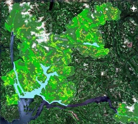
This technology offers a sweeping “eagle-eye” perspective of ecosystems with remarkable speed and scale.

However, raw remote sensing data alone can be overwhelming and difficult to interpret. Without expert ecological context, vast imagery remains noise rather than insight.
Gentian bridges this gap by uniting high-resolution satellite imagery and AI with deep ecological expertise, transforming complex habitat data into clear, quality-assured insights.
In doing so, we combine remote sensing technology with our science-driven ecological knowledge to deliver precision biodiversity monitoring that supports regulatory compliance and nature-positive decision-making.
The Challenge of Untapped Remote Sensing Data
Modern satellites continuously collect enormous volumes of environmental data—over 100 terabytes of Earth observation data every day.
The potential of this remote sensing data is immense: it delivers rapid, wide-scale coverage of forests, wetlands, and other habitats that would take teams on the ground months to survey.
Yet the critical question remains: how do you turn raw data into a reliable, quality-assured insight? Most organisations lack the specialised expertise to analyse and interpret complex satellite imagery on their own.
Raw images and spectral data are rich with detail but can be highly complex, requiring ecological knowledge to separate signal from noise.

Without context from seasoned environmental scientists, satellite data can remain an impenetrable map of colours and patterns rather than actionable findings.
This is where Gentian provides the answer. We leverage Very High Resolution (VHR) satellite imagery, meaning detail down to sub-meter levels, combined with our True Sage system to translate ecological complexity into clear, actionable intelligence. Gentian’s approach is rooted in a commitment to accuracy and insight.
In fact, Gentian has set the gold standard for data quality in biodiversity mapping, using advanced imagery and AI to deliver unmatched accuracy.
By infusing every pixel of data with deep ecological understanding, we ensure that remote sensing outputs are measurable, reliable, and impactful.
True Sage, true to its name (symbolising wisdom and truth), embodies our pursuit of knowledge-sharing and data. It sets a new industry benchmark for precision, turning raw satellite observations into insights you can trust.
Combining AI and Remote Sensing for Ecological Monitoring
At Gentian, experts with deep ecological knowledge and remote sensing pioneers work hand-in-hand, backed by leading AI specialists.
This unique blend of ecological expertise and cutting-edge data science means our insights are grounded in real-world environmental science from the start.
These AI-driven models don’t operate in a vacuum, they are trained and continually refined by our experts, ensuring that the patterns identified are scientifically sound and relevant to on-the-ground conservation needs.
Crucially, our technology isn’t just counting pixels, it’s recognising habitats, indicators, and subtle ecological changes.

For example, Gentian’s AI can distinguish individual tree canopies and linear features like hedgerows or watercourses from 50 cm satellite imagery, capturing fine details that traditional methods might miss.
It even excels at separating visually similar vegetation types and detecting small-scale disturbances in an ecosystem.
Furthermore, our habitat mapping is aligned with international classification systems (IUCN, UKHab, EUNIS), ensuring the results are directly compatible with global standards and reporting needs.
[For a deeper dive into these frameworks, see our guide to IUCN, UKHab, and EUNIS]
Every assessment is also reviewed by our team for quality assurance, guaranteeing reliable accuracy.
Our ecology-driven AI approach has already delivered real-world impact. In one case, Gentian True Sage remotely mapped over 50 sites in 90 days, revealing a 29-unit biodiversity net gain uplift for a UK client.
This demonstrated how quickly our approach can cover large portfolios while providing robust evidence of positive ecological outcomes (e.g. confirming Biodiversity Net Gain).
By marrying scientific expertise with AI and satellite data, Gentian is continually bringing forth new insights, empowering organisations to “see” nature in unprecedented ways and make proactive, nature-positive decisions.
Why This Approach is Crucial for Stakeholders
Risk Mitigation
Precision insight helps organisations anticipate ecological risks before they escalate.
Gentian’s analyses detect early warning signs, like drying vegetation that signals wildfire risk or habitat degradation near a site, so companies can intervene in time.
This makes the invisible visible, uncovering vulnerabilities that would otherwise go unnoticed and bolstering resilience.
In short, nature-related threats (wildfires, floods, etc.) become far more manageable when armed with these predictive, high-precision insights.
Compliance and Trust
Gentian’s high-quality habitat data is aligned to global standards, simplifying compliance with frameworks like TNFD and CSRD.
Outputs come in reporting-ready formats, easing compliance for in-scope large companies as the CSRD’s biodiversity disclosure requirements are phased in across the EU.
And because each analysis is reviewed by experts, clients can trust the accuracy and present results with confidence to regulators and stakeholders.
Speed and Efficiency
Gentian’s remote sensing approach delivers biodiversity insights in days or even hours, versus the weeks or months needed for traditional field surveys.
There’s no need to wait for field seasons or send large teams on-site.
Organisations can rapidly screen many locations or assess environmental impacts immediately after an event, addressing issues before delays set in. In short, our technology dramatically streamlines project timelines without sacrificing accuracy.
In summary, combining remote sensing technology with deep ecological expertise is a powerful formula for precision biodiversity monitoring.
Gentian’s approach turns streams of satellite data into actionable insight, enabling organisations to see and value nature in unprecedented ways.
Armed with these insights, organisations can better manage nature-related risks and make informed, nature-positive decisions. As the biodiversity crisis intensifies, integrating remote sensing with ecology is now essential for a sustainable future.
Partner with Gentian to unlock the future of precision remote sensing data for your environmental projects.
To discover what Gentian’s remote habitat mapping can do for you, we encourage you to get in touch or learn more about our Habitat Mapping services.