Biodiversity solutions are strategies and tools designed to address the loss of nature’s variety, from conserving habitats to offsetting environmental impacts.
As the global biodiversity crisis deepens, with around 1 million species at risk of extinction, organisations face mounting pressure to implement effective solutions to biodiversity loss. Gentian, a leader in precision biodiversity monitoring, empowers organisations to understand “the truth about nature” through AI and satellite technology.
This means providing the high-resolution data and insights needed for swift, informed decisions that protect both ecosystems and business operations.
Crucially, there is no one-size-fits-all fix - every project, whether a single field survey or a country-wide assessment, demands a tailored approach.
Gentian’s commitment to customisation and scalability ensures biodiversity solutions can be adapted to any project size, delivering consistent quality and speed at scale.
In this article, we explore how Gentian’s customisable, scalable biodiversity solutions rise to meet different project needs. We discuss small versus large-scale deployments, the power of custom data outputs for initiatives like biodiversity offsetting, and how Gentian’s expert team and cutting-edge technology make it a trusted partner for lasting impact.
Jump to Section:
- Addressing Diverse Project Sizes: From Field to County
- The Power of Customisation: Beyond Generic Biodiversity Offsetting
- Gentian’s Expertise and Technology Lead the Way
Addressing Diverse Project Sizes: From Field to County
By leveraging satellite imagery and AI, Gentian can rapidly map biodiversity at any scale, from a single field to an entire county, while maintaining the same high level of detail and accuracy.
At the core of this capability is Gentian True Oracle, our enterprise-level biodiversity and vegetation management software. True Oracle can be fully tailored to client needs, delivering anything from localised site assessments to comprehensive multi-site monitoring, without compromising on data quality, speed, or scientific precision.

This flexibility is critical for consultancies and corporations alike: a mid-sized environmental consultancy might need a quick habitat survey for a proposed development, whereas a multinational firm might require synchronised biodiversity monitoring across dozens of sites.
Gentian’s technology supports both ends of this spectrum, delivering consistent, standardised habitat data for reliable comparisons across projects of any size.
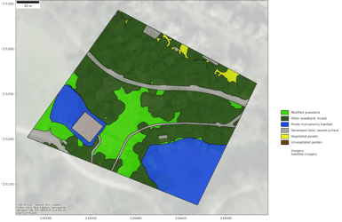
Small to Mid-Scale Projects
Smaller projects like local site assessments or ecological impact studies benefit greatly from Gentian’s precision data and efficient tools. Using ultra-high-resolution imagery (with spatial resolution of 50 cm or better), Gentian True Sage can map habitats with unparalleled precision, capturing ecological details often missed by traditional surveys.
.png?width=627&height=314&name=True%20Sage%20Graphic%20One%20(1).png)
By customising data outputs to focus on the features relevant to a site (e.g. tree cover, wetland boundaries, or species-rich grassland patches), Gentian provides exactly the information needed for the project at hand.
The result is a faster, cost-effective turnaround for site assessments: what once took ecologists weeks of fieldwork can be delivered in days or even hours, without sacrificing accuracy.
These precise, customisable insights save time and budget for small and mid-scale projects, enabling consultants to act quickly on conservation or planning decisions without waiting on lengthy surveys.
Large-Scale Multi-Site Monitoring
For large-scale initiatives, such as regional biodiversity monitoring, infrastructure projects spanning multiple counties, or portfolio-wide environmental oversight, Gentian’s ability to scale up is invaluable.
Gentian True Oracle can analyse extensive areas and numerous sites in parallel, providing a holistic view of biodiversity across a landscape or organisation.
Critically, this scaling doesn’t dilute quality: even when mapping hundreds of square kilometres or dozens of sites at once, the data retains the fine resolution and accuracy needed for confident decision-making.
In practice, this means a company could assess the habitat condition of all its landholdings in one go, or a consultancy could monitor biodiversity for an entire county’s worth of projects simultaneously. Gentian’s platform delivers automated, GIS-ready outputs for each site, such as habitat maps, which can be easily aggregated or examined individually via a web dashboard or API.
One notable example of large-scale scalability is a recent project where Gentian True Sage mapped 50+ sites in 90 days for a UK land operator, identifying a substantial biodiversity net gain across the portfolio.
By remotely surveying multiple locations with AI, Gentian drastically cut down costs and time compared to sequential field surveys. Moreover, the consistent methodology ensures that results from different sites are directly comparable, a crucial benefit for large organisations aiming to standardise their environmental reporting.
In summary, Gentian enables comprehensive biodiversity monitoring at scale, turning what could be an overwhelming multi-site challenge into a streamlined process with reliable, high-quality data across the board.
The Power of Customisation: Beyond Generic Biodiversity Offsetting
Biodiversity challenges are diverse, and so are the data requirements for tackling them. Biodiversity offsetting, for instance, is a widely used approach to compensate for habitat loss, but doing it well requires nuanced, project-specific data rather than generic metrics. Critics note that traditional offset schemes often rely on simplistic, one-size-fits-all metrics that risk overlooking important ecological details.
Gentian True Oracle addresses this gap by providing a customisable, enterprise-level biodiversity and vegetation management solution. Unlike generic monitoring tools, True Oracle adapts to the specific needs of each project and stakeholder.
Its AI-powered analytics and ultra-high-resolution imagery can be configured to highlight the information that matters most—whether that’s monitoring urban biodiversity on a single city block, tracking invasive species, or evaluating habitat restoration success.
For example, Gentian partnered with Scottish Power to develop a bespoke peatland monitoring solution using Gentian True Oracle. By combining satellite imagery with AI-driven analysis, True Oracle delivered full-site assessments in just days, identifying peatland degradation, invasive species, and restoration outcomes.
This approach gave Scottish Power 100% site coverage, cut monitoring costs by up to 50%, and provided the timely insights needed to ensure NatureScot compliance and strengthen their carbon and biodiversity commitments.

This flexibility extends beyond restoration. True Oracle can tailor habitat classifications and biodiversity indicators to align with whichever framework or standard you’re working with.
For instance, a development project aiming to achieve Biodiversity Net Gain (BNG) can use True Oracle to output baseline habitat units and forecast uplift potential. Similarly, corporations reporting under TNFD or the EU CSRD can generate customised ecological metrics and spatial layers that slot seamlessly into disclosure requirements.
By moving beyond generic reports and instead providing decision-useful, context-specific insights, True Oracle empowers organisations to implement biodiversity offsetting and conservation actions that reflect the unique ecological realities of their projects, ensuring compliance, credibility, and lasting impact.
Gentian’s Expertise and Technology Lead the Way
Gentian’s strength lies not only in its data but in the visionary expertise and innovative technology behind that data. By combining a world-class team of specialists with cutting-edge AI and Earth observation techniques, Gentian delivers effective biodiversity solutions for even the most complex environmental challenges.
Visionary Expertise
At the helm of Gentian is a multidisciplinary team of ecologists, AI specialists, and remote-sensing pioneers dedicated to advancing our understanding of nature. This rich expertise ensures that Gentian’s tools are grounded in ecological reality even as they push technological frontiers.
Gentian’s leadership has decades of combined experience in fields like habitat management, environmental policy, and Earth observation (including contributions to major space agency missions), underscoring its credibility.
This visionary blend of ecology and technology helps bridge the gap between raw data and real-world application, enabling clients to see and value the habitats they impact in ways not previously possible. In short, Gentian’s expert team ensures that the focus remains on actionable insights and thoughtful stewardship of nature, rather than technology for its own sake.
Innovative Technology
Driving Gentian’s solutions is a suite of AI-driven models that analyse environmental data with unparalleled precision. True Sage, for example, uses advanced machine learning to classify satellite imagery into detailed habitat maps, recognising everything from broad ecosystems down to individual trees or green roofs in a cityscape.
The use of very high-resolution satellite imagery (often <50 cm per pixel) means the platform can detect fine-scale changes and subtle patterns that traditional remote sensing or manual surveys might miss.

What sets Gentian apart is how it has moved beyond simple vegetation mapping, the technology can distinguish nuanced habitat types, monitor invasive species spread, quantify biodiversity metrics like habitat connectivity or diversity indices, and even identify opportunities for ecological uplift or restoration.
Moreover, Gentian’s cloud-based platform processes this data at remarkable speed, delivering results in days or even hours. This combination of accuracy and speed is crucial for clients facing tight regulatory deadlines or the need to respond quickly to environmental risks.
Whether it’s analysing a single site or an entire supply chain’s footprint, Gentian’s innovative technology ensures that biodiversity insights are both unmatched in detail and delivered with agility, giving organisations a powerful edge in addressing their environmental challenges.
Becoming a Trusted Partner for Lasting Impact
Beyond the data and tools, Gentian distinguishes itself as a trusted partner committed to each client’s long-term success. The company’s philosophy is not to drop off a report and disappear, but to work alongside organisations in building scalable, flexible solutions that evolve with their needs.
As regulatory landscapes and project scopes change, Gentian’s support and services can adapt, whether scaling up monitoring as a business expands or refining analytics to focus on new conservation targets.
This partnership approach is underpinned by Gentian’s emphasis on continuous monitoring for long-term insights. Instead of one-off snapshots, Gentian enables ongoing biodiversity surveillance, so clients can track changes in habitats and ecosystems over time.
This is invaluable for spotting trends or emerging risks early: for instance, detecting a gradual decline in habitat quality before it becomes a critical problem, or conversely, verifying that restoration efforts are yielding positive results year over year.
By quickly identifying such trends, organisations can adjust their strategies proactively, reinforcing successful measures or mitigating new threats. The outcome is a lasting impact:
Gentian’s clients gain not just compliance or a checkbox exercise, but a dynamic understanding of nature that informs resilient decision-making. In empowering clients with ongoing, actionable biodiversity intelligence, Gentian truly partners in their journey towards sustainable operations and nature-positive outcomes.
Rely on Gentian for Tailored Biodiversity Solutions
In the face of an unprecedented biodiversity crisis, organisations need solutions that are both effective and adaptable. Gentian’s customisable and scalable approach ensures that every project, regardless of size or complexity, gets the precise biodiversity solution it requires, no more, no less.
By tailoring high-quality data to on-the-ground realities, Gentian helps clients achieve meaningful progress in combating biodiversity loss while also meeting compliance obligations and business goals. From accelerating small site assessments to powering large-scale offsetting programs, Gentian’s technology turns biodiversity insights into tangible action.
Ready to take the next step? Discover how Gentian True Oracle can be custom-fit to your project’s needs, or contact our team to learn more about empowering your organisation with precision biodiversity insights.