.jpg?width=2049&height=1550&name=hunter-masters-NFIhAk0hlgk-unsplash%20resized%20(1).jpg)
Biodiversity mapping tools
for site scoping, monitoring, and reporting
From rapid site scoping to portfolio-scale monitoring and reporting, we classify habitats to recognised standards to support nature-positive planning, nature-related risk, and TNFD-aligned reporting.
.webp?width=1540&height=558&name=GFSA_DigitalBadge_withoutyear_2024%20(1).webp)

What we do
Gentian provides powerful AI technology trained to analyze Very High Resolution satellite imagery. We deliver a clear, expert view of nature directly to your fingertips. Our solutions go beyond simple vegetation mapping, empowering organizations to classify habitats, monitor invasive species, quantify biodiversity, and accurately identify opportunities for ecological uplift.
Precise biodiversity data
Gentian sets the gold standard in biodiversity mapping, utilizing satellite imagery and AI to deliver unmatched accuracy. Our data uncovers critical ecological details that are often overlooked, empowering your organization to make confident, informed decisions.
Unmatched speed and ease
Gentian sets the gold standard in biodiversity mapping, using satellite imagery and AI to deliver unmatched accuracy. Our data reveals often overlooked ecological details, empowering you to make confident, informed decisions for your organization.
Visionary expertise
A team led by ecologists, AI specialists, and remote sensing pioneers, Gentian transforms complex nature data into clear, actionable intelligence. We bridge the gap between technology and ecology, empowering organizations to see and value the habitats they impact.
A trusted partner
We don’t just provide data, we build lasting partnerships. Gentian’s solutions scale with your needs, and our biodiversity reporting delivers reliable insights that support compliance, resilience, and nature-positive action for businesses, governments, and consultancies worldwide.
.jpg?width=5184&height=3888&name=neil-macc-gMdMfO2C5GI-unsplash%20(1).jpg)
Data collection
After selecting your site, we acquire very high-resolution satellite imagery for analysis.
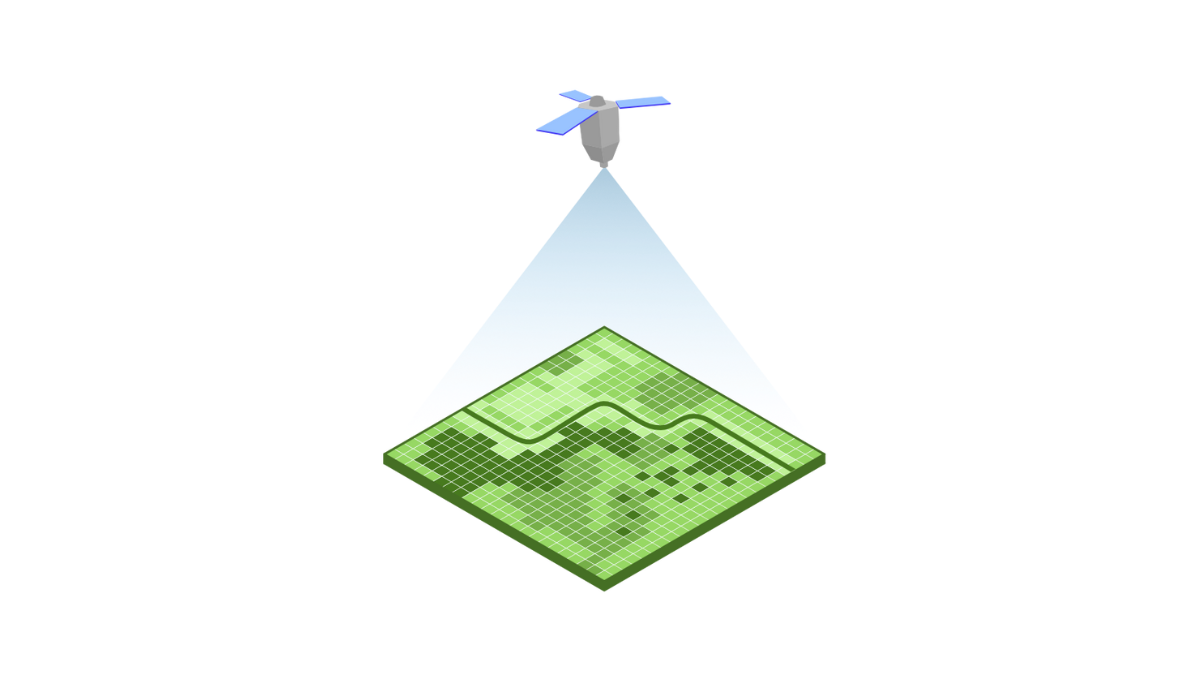
Data analysis
Our cutting-edge AI models deliver high-fidelity habitat data, which our ecological specialists rigorously verify.
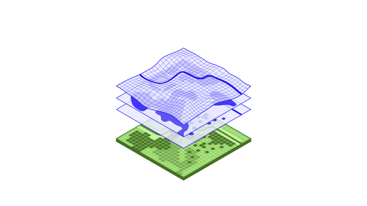
Data delivery
Access expert-verified results within days—or even minutes—through our online platform.
.png?width=1920&height=1080&name=Untitled%20design%20(2).png)
 Biodiversity Assessment
BNG Baselines
BNG Monitoring
Biodiversity Baselines
Biodiversity Monitoring
Phase 1 Habitat Surveys
 Nature-related Reporting
TNFD Reporting
CSRD Compliance
Comply confidently with the Corporate Sustainability Reporting Directive (CSRD) using our solutions that offer accurate, transparent data for sustainability reporting.
Monitoring Reporting and Verification (MRV)
Carbon Reporting
ESG Reporting
 Nature Restoration & Conservation
Peatland Mapping & Assessment
Obtain high-resolution insights into peatland extent and conditions, enabling targeted restoration and conservation efforts.
Tree Surveys
Invasive Species Detection
Regenerative Agriculture
R&D
 Urban Biodiversity & Climate Resilience
Tree Identification
Green Roof & Biosolar Identification
Flood Risk Identification
Land Use Change
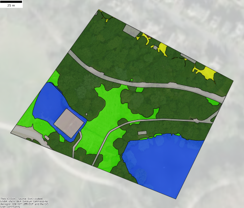

Gentian True Sight
Instant site screening. Rapid, AI-powered habitat mapping for feasibility studies and due diligence. Ideal for identifying early-stage nature risks and opportunities at speed.
.png?width=952&height=671&name=unnamed%20(4).png)

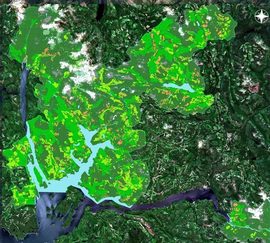
Gentian True Sage
Precision monitoring & assessment. Comprehensive biodiversity mapping designed for investor-grade reporting, strategic planning, and ongoing monitoring.

Gentian True Oracle
Enterprise nature intelligence. Tailored AI-driven insights solving complex, large-scale ecological challenges and operational risk management for global organizations.
.png?width=2048&height=690&name=unnamed%20(2).png)

Gentian True Urban
Urban green infrastructure analysis. Detailed mapping of urban habitats, green roofs, and climate resilience to support sustainable city planning and development.

Globally scalable
Deploy biodiversity MRV across your entire global portfolio with consistent precision.

Fully remote
Eliminate seasonal bottlenecks and fieldwork delays for year-round data availability.
.png?width=96&height=96&name=icons8-pass-96%20(1).png)
Aligned with frameworks
Data outputs designed for seamless integration with TNFD, SBTN, and global reporting standards.
.png?width=100&height=100&name=icons8-trust-100%20(1).png)
Trusted expertise
AI insights rigorously verified by ecologists and GIS experts for investor-grade confidence.
Why Gentian
Led by experts in ecology, remote sensing, and artificial intelligence, our biodiversity software makes the invisible visible by illuminating the risks and opportunities of your organization’s environmental footprint. Leaders powered by Gentian are better equipped to proactively manage nature-related risks, meet investor expectations, and drive sustainability innovation.


Latest News & Articles
.jpg?width=400&height=250&name=dominik-vanyi-Mk2ls9UBO2E-unsplash%20(1).jpg)
Gentian Field Notes: Critical mineral finance, the Global Nature Summit in Manchester, the ESA New Space Workshop, and more

England’s New BNG Rules: Small Sites Exempt – What It Means

How NEPA Environmental Reviews Are Changing Under Faster Permitting Timelines
.jpg?width=400&height=250&name=istvan-hernek-mcVMjHFG3a4-unsplash%20(3).jpg)